Municipal elections are coming up fast.
All one has to do is look at the number of politicians announcing their run for mayor to see just how quickly the city is gearing up for election season. However, some residents may be voting for different councillors in different districts than before.
In January, electoral boundaries in HRM shifted around after the Nova Scotia Utility and Review Board (UARB) signed off on the changes regarding the municipality’s 16 districts and their voting populations.
A municipality is required to apply to change electoral boundaries to the UARB every eight years as per the Municipal Government Act. This is to keep parity between voters and the electoral population in each district relatively even and ensure each community's needs will be represented.
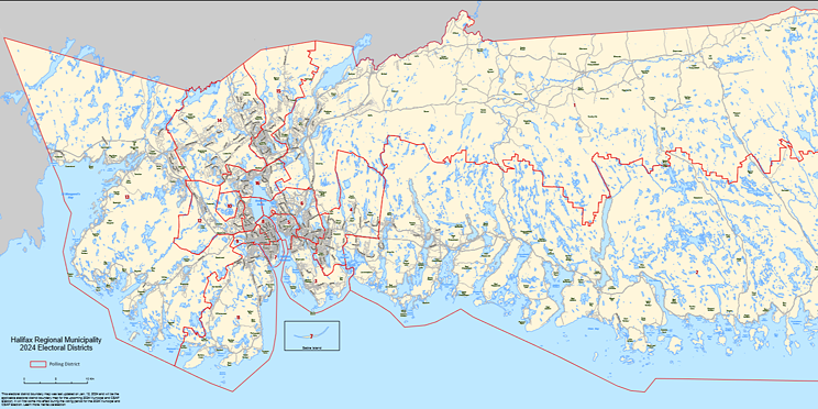
If you’ve ever looked at the electoral boundaries map for HRM, you may notice some districts, such as 7 and 8, are much smaller than the outermost districts, such as 1 and 2. It may be obvious to some, but this is a result of the city having a higher population density than other parts of HRM.
To keep the relative voting power of each district fair and equal, the UARB typically requires each municipality in the province to keep its electoral districts—and therefore its voting populations—within a variance of plus or minus 10 per cent, though exceptions can be made depending on the circumstance up to a 25 per cent variance.
The municipality may also apply to have its number of districts increased, and while HRM had previously put forward a motion to do so in their 2016 application, their request for 20 districts was shot down by the UARB.
This is all dictated through the Municipal Government Act, which requires the UARB to “consider the number of electors, relative parity of voting power, population density, community of interest and geographic size” when deciding whether to change electoral boundaries.
The actual change residents will see is this—if you happen to live in a district that had its boundaries rearranged during this process, you very well may be in a different district than you were during the last election, depending on where you live. This affects which district’s candidates you’ll be voting for in the fall.
With the municipal election coming up on Oct. 19, here’s what you need to know about the new electoral boundaries.
Boundary changes
HRM submitted its Phase Two report of the electoral boundary review on Nov. 24, 2022. This report was conducted by the District Boundary Resident Review Panel, which council approved the creation of in February 2022.
While there were several changes passed by the UARB without any issues, there were others that drew criticism from residents and were altered by the UARB after the panel submitted its report.
It was proposed that District 1 stay relatively the same. Lake Charles and Craigburn Drive were removed and placed within District 6 (Dartmouth), as public feedback indicated residents were more in line with Dartmouth than Waverely or Fall River. A small area of Beaver Bank was also removed to better follow the edge of the Wellington community boundary.
With these changes, District 1 has a voter count of around 17,702—a variance of -23.9 per cent. The review panel argued this district needed to be maintained rather than fused with another since it’s largely rural and is separate from the Eastern Shore. They also stated areas such as Fall River were likely to see population growth in the coming years.
District 2 saw North Preston and East Preston, two historically African Nova Scotian communities, turned over to District 4. While this put their voter count at a variance of -10.9 per cent with around 20,726 voters in total, the panel said this would balance voter parity and maintain communities of interest.
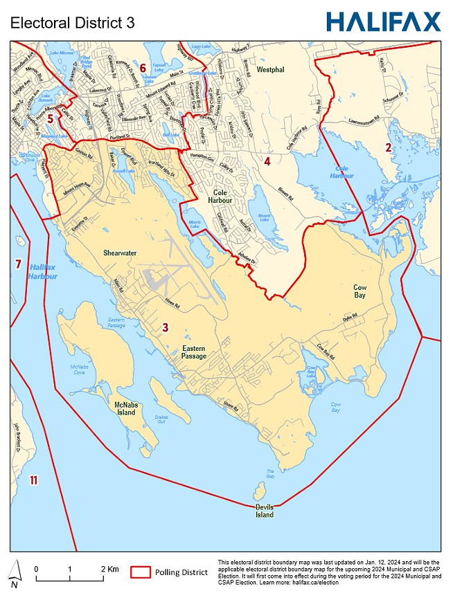
District 3 lost a portion of the Woodlawn area in District 6 to keep it as a community of interest, as well as the area south of Pleasant Street along the harbour. This includes the North Woodside and Southdale neighbourhoods in Dartmouth, as well as the area of Newcastle Street and businesses along the harbour. Pleasant Street north from the harbour and extending towards Woodside near the ferry terminal now acts as a boundary between districts 3 and 5. The elector count for this area is around 25,326, with a variance of +3.4 per cent.
District 4 now contains North and East Preston so they can remain with the other historical African Nova Scotian communities of Cherry Brook and Lake Loon, a change which saw public support according to the panel’s documentation. Although it is slightly under average with 22,887 voters and a -1.6 per cent variance, Cole Harbour was kept together as one electoral district so it would remain a community of interest.
District 5 also had its section of Woodside removed, as well as Southdale, Penhorn, and Manor Park to be paired with North Woodside and Southdale neighbourhoods that were brought over from District 3 to District 6. North Dartmouth, Highfield Park, Shannon Park and the Princess Margaret Boulevard areas were brought over from District 6 into District 5, and the UARB ruled that the area south of Pleasant Street along the harbour up to Woodside be included in District 5. They now have a voting population of around 25,684 with a variance of +15.9 per cent.
District 6 gained the Lake Charles and Craigburn Drive area south of Highway 107 from District 1, and now includes all of the Woodlawn area to keep it as a community of interest. It lost North Dartmouth, Highfield Park, Shannon Park, and Princess Margaret Boulevard to District 5 so they could be kept together with other parts of central Dartmouth. It also includes areas of Penhorn and Manor Park. The total elector count is around 23,006 with a variance of -1.1 per cent. If you’re keeping track, that’s the closest to the average we’ve seen so far, though this is likely to change due to population growth in the area.
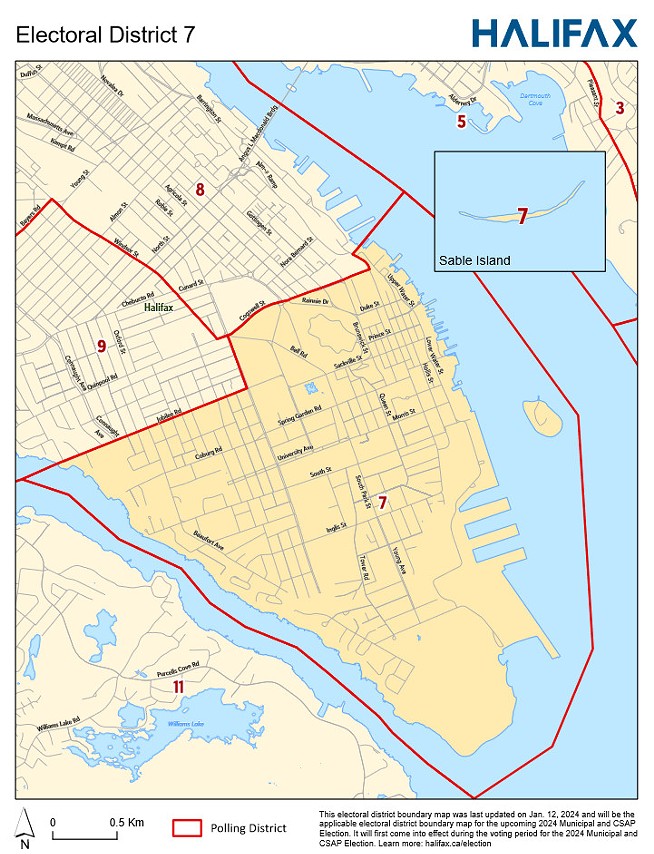
District 7 saw several changes, bringing its variance from +15.2 per cent down to just +1.9 per cent. This is, in part, to account for future population growth in Halifax’s South End. Changes include the removal of the area bounded by Quinpool Road, Robie Street, Jubilee Road, and Oxford Street. This was contested, but the panel argued it was needed to keep parity amongst voters.
The district also saw the removal of the area bounded by Nora Bernard Street, the Halifax Harbour, Cogswell Street, and the Halifax Citadel as it was found to be more in line with communities of interest in Halifax’s North End, which is mostly central to District 8.
District 8 accepted the areas of Nora Bernard Street, the Halifax Harbour, Cogswell Street, and the Halifax Citadel while removing the area bounded by Windsor Street, Quinpool Road, Oxford Street, and Bayers Road in an attempt to keep the West End together as a community of interest. While it’s below the average number of electors at 21,655—a variance of -6.9 per cent—growth is likely to take place as housing units continue to be developed.
District 9 has a variance of -0.8 per cent off of the average with a total voter count of about 23,087. Changes include accepting the area bounded by Windsor Street, Quinpool Road, Robie Street, Jubilee Road, Oxford Street, and Bayers Road, part of which was previously in districts 7 and 8. Removed from the district were Cowie Hill and Jollimore areas so they may be paired with Spryfield as a community of interest in District 11. Long Lake Provincial Park is now split between districts 9 and 11 after a decision by the UARB.
District 10 was adjusted only slightly, excluding properties off of Hogan Court so the street remains in a single district and so it follows the community boundary. Thanks to public feedback, the Blue Mountain – Birch Cove Lakes National Urban Park has also been added to District 10 as per a decision from the UARB. It has a variance of -1.3 per cent.
District 11 now includes Cowie Hill and Jollimore areas, keeping them together with Spryfield as a community of interest. This includes communities accessed by Herring Cove Road, Purcells Cove Road, and Old Sambro Road. It also contains part of Long Lake Provincial Park as per a decision made by the UARB. Communities accessed by Prospect Road—Terence Bay to West Dover—were removed from this district. The variance is +4.3 per cent with a total elector count of around 24,258.
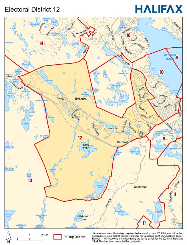
District 12 now includes the area around Ragged Lake so it may be included with the Beechville area. It also includes the Sheldrake Lake area to keep the neighbourhood with other parts of Timberlea. While it has a variance of +10.6 per cent, staff argued any subtractions would divide communities of interest.
District 13 picked up communities accessible via Prospect Road (from Terence Bay to West Dover) and removed the communities of Upper Hammonds Plains, Hammonds Plains, and Lucasville so Upper Hammonds Plains and Lucasville could remain together as a historic African Nova Scotian community in District 14. The variance is -12.5 per cent, but staff said the district’s geographical area was large, allowing rural voters “to have their own representation.”
District 14 now includes Upper Hammonds Plains and Lucasville, as well as Hammonds Plains and Sandy Lake Regional Park, the latter to establish Highway 102 as a natural boundary between districts 14 and 16. Removed from this district were Bedford West sub-areas 7 and 8 to keep them together with Bedford West, as well as Beaver Bank and Kinsac to keep them with Lower Sackville in District 15 for their similarities. The variance is the closest to the average out of all of HRM’s electoral boundaries at -0.5 per cent with 23,148 electors total.
District 15 now includes Beaver Bank and Kinsac alongside Lower Sackville, leaving the district with a variance of +7.2 per cent with around 24,943 electors.
District 16 accepted Bedford West sub-areas 7 and 8 to keep them alongside the rest of Bedford West, as well as Hogan Court so the electoral boundary could follow the community boundary. It lost Sandy Lake Regional Park to District 14. While the variance is +16.2 per cent with an elector count of around 27,033, public feedback supported grouping Bedford West with the old Town of Bedford as Bedford West’s inclusion in District 14 could have meant the suburban/rural residents of the district would have had their interests overshadowed by the more populous Bedford West.
Thankfully, HRM also provides maps of its districts on its website, so if you’re still unsure of where you’re voting this election, be sure to check those out.

